Char Dham Yatra — Four Shrines, Four Rivers, One Complete Picture of the Garhwal Himalayas

Description

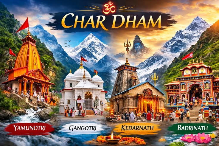
The Char Dham circuit has been travelled for over twelve centuries. Adi Shankaracharya established it in the 8th century to connect the sacred geography of the Garhwal Himalayas into a single pilgrimage. The four shrines — Yamunotri, Gangotri, Kedarnath, Badrinath — sit at or near the sources of four of North India’s most significant rivers: the Yamuna, the Ganga, the Mandakini, and the Alaknanda.

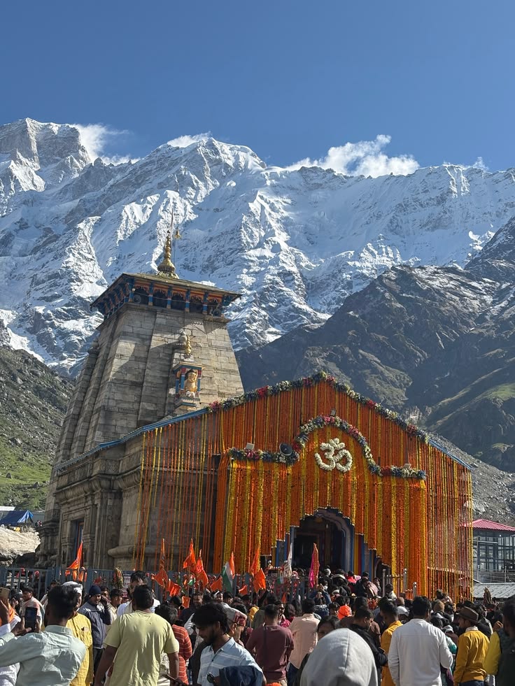
What strikes most first-time visitors is how different the four places are from each other. Yamunotri is tight and forested, the trail hemmed in by a narrow gorge. Gangotri is open and glacial, sitting beside a roaring river in a deodar forest at 3,048 metres. Kedarnath occupies a broad mountain amphitheatre with glaciated peaks on three sides — one of the most dramatic settings for any temple in India. Badrinath has the scale and energy of an ancient city, with a proper town built up around the temple and the Alaknanda running noisily below the ghats.

Two of the four — Yamunotri and Kedarnath — require trekking. Gangotri and Badrinath are motorable to the temple entrance. For those who want to extend the journey, Gomukh glacier — the documented source of the Ganga, 19 km beyond Gangotri — adds two days and transforms the trip into something more complete.

One recommendation that is worth making clearly: stay overnight at Kedarnath. The morning aarti at 4 AM, inside the temple with the bells going and the peaks visible through the pre-dawn cold outside, is a completely different experience from an afternoon darshan. If there is one night on this circuit not to cut for the sake of saving time, this is it.

Four Dhams at a Glance

ShrineRiverAltitudeHow to Get to Temple
YamunotriYamuna10,804 ft6 km trek from Janki Chatti
GangotriGanga (Bhagirathi)10,312 ftMotorable (Gomukh glacier: 19 km further)
KedarnathMandakini11,755 ft16 km trek from Gaurikund
BadrinathAlaknanda10,279 ftMotorable

The Significance of Each Shrine

Yamunotri

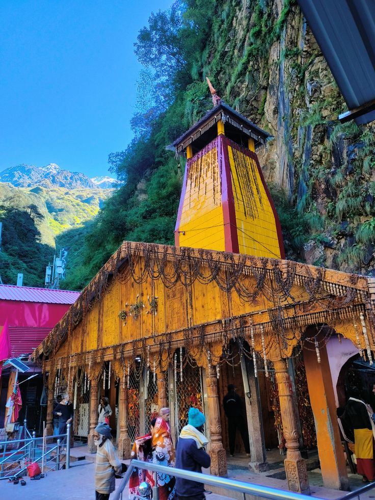
The westernmost of the four dhams and the ritual starting point of the circuit. The temple sits at the source of the Yamuna river at 10,804 feet. The trail from Janki Chatti follows the gorge — narrow, steep in sections, and very different in character from the open landscapes of the other three sites. Hot water springs beside the temple have been used by pilgrims for centuries to cook rice as prasad — a practice that has continued unchanged.

Gangotri

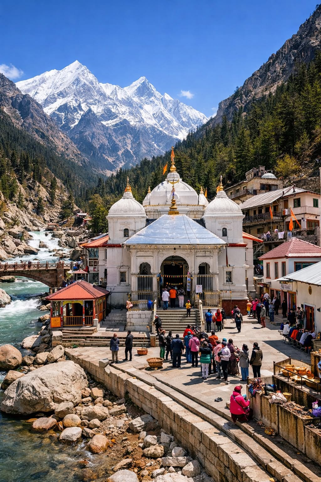
At 10,312 feet beside the Bhagirathi river in a deodar forest, Gangotri is where the Ganga is ritually worshipped at its origin. The actual glacial source — Gomukh — is 19 km further, accessible by a separate two-day trek that many pilgrims add on. The town itself has grown around the temple but the forest and the river give it a different quality from Kedarnath and Badrinath. Early mornings here, before the tourist buses arrive, are worth waking up for.

Kedarnath

One of the twelve Jyotirlingas and the most physically demanding of the four dhams. The 16 km trek from Gaurikund climbs steadily to the temple at 11,755 feet in a valley ringed by peaks. The temple structure itself is ancient stone, austere and powerful. Helicopter service is available from Phata and Guptkashi for those who cannot manage the trek. The overnight stay for the 4 AM aarti is strongly recommended — few experiences in the mountains match it.

Badrinath

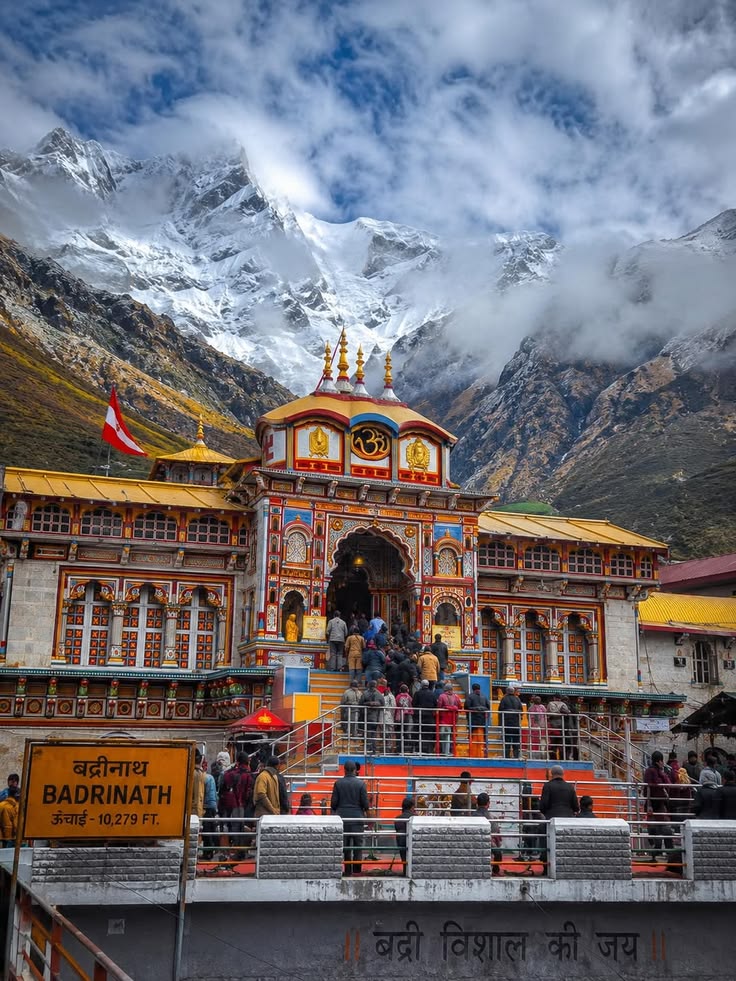
The northernmost of the four dhams, at 10,279 feet on the Alaknanda river in the shadow of Neelkanth peak. Badrinath has been a major pilgrimage site for thousands of years and the town that has grown around it reflects that long history. The temple itself is brightly painted and architecturally distinct from the other three. Three kilometres further is Mana — the last Indian village before Tibet, worth a full half-day of exploration on its own.

How to Reach the Circuit

Haridwar or Rishikesh is the standard base. The conventional circuit order — Yamunotri, Gangotri, Kedarnath, Badrinath — runs east to west and then north, allowing logical road transfers between sites.

Key roads:

  • NH94: Rishikesh → Uttarkashi → Gangotri (and Barkot for Yamunotri approach)
  • NH58: Rishikesh → Rudraprayag → Joshimath → Badrinath (and branch roads for Gaurikund/Kedarnath)

Both roads are maintained by the Border Roads Organisation and are generally in good condition during the May to October open season.

Practical Planning Guide

Temple Opening Dates

All four temples open on Akshaya Tritiya in May — the exact date shifts each year with the Hindu calendar and is announced weeks before the season. Closing dates fall around Diwali and Bhai Dooj in October to November. Check current dates before finalising travel.

Kedarnath Registration

The Uttarakhand government operates a mandatory pilgrim registration system for Kedarnath, with daily entry quotas. Registration is done online and should be completed as early as possible — slots fill well before the season. Your trekking operator can assist with this.

Helicopter Bookings

Kedarnath helicopter services from Phata and Guptkashi are among the most in-demand bookings in the mountains. Open for reservation months before the season starts and fill up extremely fast. If flying is part of your plan, book the moment reservations open.

Accommodation

GMVN (Garhwal Mandal Vikas Nigam) operates guesthouses at all four dhams — reliable, government-managed, and reasonably priced. Private options are also available at all sites. Pre-booking is essential from mid-May through June and through September.

Altitude Considerations

Kedarnath at 11,755 feet is the highest overnight point for most pilgrims. People with cardiovascular conditions, respiratory issues, or a history of altitude sickness should consult a doctor before planning. The ascent from Gaurikund is gradual but covers significant elevation in a single day.

Road Conditions and Monsoon

The Char Dham highways are well maintained but subject to landslides, particularly during the July to August monsoon. Most organised circuits avoid this window entirely. The BRO publishes road status updates regularly; your operator will monitor these.


Highlights Icon

Highlights

  • Four Completely Different Himalayan Landscapes — Yamunotri's narrow gorge, Gangotri's open deodar forest beside the Bhagirathi, Kedarnath's dramatic glaciated amphitheatre, and Badrinath's ancient town on the Alaknanda — no two are remotely similar. One circuit, four distinct worlds.
  • Kedarnath at 4 AM — The morning aarti inside one of India's twelve Jyotirlingas, by butter lamp light with the bells building and the peaks visible through the open temple door in the pre-dawn cold. The overnight stay is the single most important decision of the entire Yatra.
  • Yamunotri's Hot Springs Prasad — The tradition of cooking rice in the thermal springs beside the Yamunotri temple has continued for centuries without interruption. Standing there with the steam rising around the stone channels is one of those moments where history and the present are happening simultaneously.
  • Gangotri's Deodar Forest — The drive from Uttarkashi to Gangotri passes through some of the finest deodar forest in the Indian Himalaya. The forest and the roaring Bhagirathi give Gangotri a character that is wilder and less town-like than the other three dhams.
  • Mana Village and the Sources — Three kilometres beyond Badrinath, Mana is India's last village before Tibet. The Saraswati river disappears underground here — visibly, dramatically — and the Vyas Gufa and Bhim Pul are within walking distance. A half-day here closes the Yatra with a landscape that still feels ancient.
  • Twelve Centuries of Continuity — Adi Shankaracharya established this circuit in the 8th century. Walking it in the 21st century, the mountains, the rivers, and the rituals at the temples are unchanged. That continuity is not a tourist feature — it is simply what the Char Dham is.

Included

  • Accommodation throughout — guesthouses/hotels at all four dhams and en route towns on twin sharing basis
  • All meals from Day 1 dinner to the final day's breakfast
  • All temple-related logistics, including Kedarnath pilgrim registration assistance
  • Private or shared vehicle transport for the entire circuit
  • Guide/coordinator support throughout the journey
  • First aid kit and basic medical support

Excluded

  • Helicopter charges for Kedarnath (if opted for instead of the trek)
  • Pony, doli, or palki charges at Kedarnath and Yamunotri
  • Personal expenses, donations, and temple offerings
  • Travel insurance
  • Meals not specified in the itinerary
  • Anything not specifically mentioned under inclusions

Travel Itinerary

Day 1 - Rishikesh / Haridwar to Barkot

Drive | 6–7 hours | Altitude: 4,900 ft

Morning departure from Rishikesh or Haridwar. The road heads northeast through Dehradun and climbs past Mussoorie before turning into the Yamuna valley. Barkot at around 4,900 feet is the base town for the Yamunotri approach — a small mountain settlement with guesthouses and restaurants. Arrive by late afternoon, check in, and eat an early dinner. The first trekking section of the Yatra is tomorrow.

Day 2 - Barkot to Janki Chatti, Trek to Yamunotri and Back

Drive + Trek | 12 km round trip | Altitude: 10,804 ft at Yamunotri

A 35 km morning drive brings you to Janki Chatti — the trailhead for Yamunotri. The 6 km trail follows the Yamuna gorge upward, narrow and forested, with the river audible below for most of the climb. The Yamunotri temple sits at 10,804 feet at the river's origin point. Beside it, the thermal springs — Surya Kund and Gauri Kund — have been used by pilgrims for centuries to cook rice and potatoes as prasad in the boiling water. The steam rising from the stone channels in the cold mountain air is one of the most distinctive sensory memories of the entire Yatra. Pony and doli services are available for those who need them on the trail. Return to Janki Chatti or Barkot for the night.

Day 3 - Barkot to Uttarkashi

Drive | 3–4 hours | Altitude: 3,300 ft

Morning departure from Barkot. The road descends from the Yamuna valley and crosses into the Bhagirathi region. Uttarkashi is a proper Himalayan market town — worth an hour of walking around the bazaar, a visit to the Kashi Vishwanath temple, and a good meal before the Gangotri drive tomorrow. Overnight here.

Day 4 - Uttarkashi to Gangotri

Drive + Temple Visit | 3–4 hours | Altitude: 10,312 ft

The drive from Uttarkashi to Gangotri follows the Bhagirathi upstream through one of the finest continuous stretches of deodar forest in the Garhwal Himalaya. The trees close in on both sides of the road, the river runs loud below, and the air becomes colder and cleaner with each kilometre of altitude. Gangotri at 3,048 metres sits directly beside the Bhagirathi. The temple is simpler and less ornate than Badrinath — stone, austere, and powerful in its setting. The river here is a deep glacial green, nothing like the flat plains river it becomes in the lowlands. Attend the evening aarti beside the water. Overnight in Gangotri. Those adding Gomukh glacier — 19 km further and two additional days — should plan their extension from here.

Day 5 - Gangotri to Guptkashi

Drive | 6–7 hours | Altitude: 3,900 ft

The longest driving day of the circuit and the most scenically varied. The road descends the tight Bhagirathi gorge all the way back to Uttarkashi, then continues south to the Alaknanda highway at Rudraprayag, then turns northeast up the Mandakini valley toward the Kedarnath region. Three completely different valley systems in one day of driving. Overnight in Guptkashi or Phata — both are well-equipped base towns for Kedarnath, and helicopter services originate from Phata and nearby Sersi.

Day 6 - Guptkashi to Gaurikund, Trek to Kedarnath

Drive + Trek | 16 km uphill | Altitude: 6,578 ft → 11,755 ft

Short drive from Guptkashi to Gaurikund. The 16 km trail to Kedarnath begins at the Gaurikund gate. The climb is steady and sustained — not brutally steep in any single section but long enough that the arrival at the temple feels earned. Ponies and dolis are available throughout the route. Helicopter from Phata or Sersi cuts the climb entirely — book months in advance as slots fill fast. Check into the guesthouse at Kedarnath, rest through the afternoon, and attend the evening aarti. Sleep early. The most important moment of the Yatra starts at 3:30 AM.

Day 7 - Morning Aarti at Kedarnath, Descent to Gaurikund

Trek | 16 km downhill | 4–5 hours

The alarm goes at 3:30 AM. Outside the lodge it is dark and cold in a way that is specific to Kedarnath — the kind of cold that comes from being surrounded by glaciated peaks at nearly 12,000 feet. The lane to the temple is already moving with people carrying lamps and wrapped in shawls, and the sound of bells begins before you reach the entrance.

The 4 AM aarti inside Kedarnath is one of those experiences that is genuinely difficult to convey to someone who has not been there. The sanctum is lit by diyas and the glow of butter lamps. The priests carry out the ritual with the same precision they have followed every morning for generations. The bells build through the stone interior, the chants fill the air, and through the open temple door, the first grey light is beginning to touch the peaks above the valley. No crowd management, no tourist queue at this hour — just the aarti, the cold, and the mountains. After the ceremony, eat breakfast, and begin the 16 km descent. Reach Gaurikund by early afternoon.

Day 8 - Gaurikund to Badrinath

Drive | 5 hours via Rudraprayag and Joshimath | Altitude: 10,279 ft

The final major road transfer of the circuit. The Alaknanda highway heads north from Rudraprayag through Chamoli and past Joshimath before the valley narrows and Badrinath appears with Neelkanth peak rising directly above it. The town has grown significantly around the temple but the mountain and the river have not changed. Check in, rest through the afternoon, and attend the evening aarti at the temple ghats beside the Alaknanda.

Day 9 - Badrinath Temple Darshan and Mana Village

Full day at 10,279 ft

Morning aarti at Badrinath temple — begin the day here before the pilgrim crowds build. The Badrinath temple is architecturally the most distinctive of the four dhams — brightly painted stone, elaborate spire, the Alaknanda running directly below the courtyard. After darshan, the surrounding area is worth a morning of exploration: the Tapt Kund hot springs beside the river, the Brahma Kapal ghat used for ancestral rituals, and the views up the valley toward the Himalayan peaks that frame the town on three sides.

Mana village, 3 km up the road from Badrinath, is India's last settlement before the Tibet border. The Saraswati river disappears underground here at a specific, documented, visible point just outside the village — a phenomenon found nowhere else in the country. The Vyas Gufa cave, where the Mahabharata is traditionally said to have been dictated by Vyas Muni, is a short walk from the village centre. The Bhim Pul natural stone bridge spans the Saraswati's final above-ground stretch. For those with energy, Vasudhara Falls — a 122-metre cascade 9 km further into the valley — is a full half-day excursion that is worth every step. Return to Badrinath for the final night.

Day 10 - Badrinath to Joshimath or Rudraprayag

Drive | 3–4 hours

Begin the return journey. The descent from Badrinath through the Alaknanda valley feels different from the drive up — the mountains that filled the windscreen for ten days are now behind you. Overnight in Joshimath at 6,150 feet or push further to Rudraprayag depending on pace.

Day 11 - Joshimath or Rudraprayag to Devprayag or Rishikesh

Drive | 4–6 hours

The return covers familiar highway ground — Chamoli, Karnaprayag, Rudraprayag. Stop at Devprayag — where the Bhagirathi and Alaknanda converge to form the Ganga. You crossed this confluence on Day 1 heading out. Coming back to it from the other direction, having just spent nearly two weeks following these rivers to their origins in the high mountains, gives the spot an entirely different meaning. Overnight in Devprayag, Rishikesh, or Haridwar depending on how far the day's driving goes.

Frequently Asked Questions

Do I need to register in advance for Char Dham Yatra?

Yes, particularly for Kedarnath, where the Uttarakhand government operates a mandatory online pilgrim registration system with daily quotas. Registration should be completed well before travel.

Is Char Dham Yatra physically demanding?

Two of the four shrines — Yamunotri and Kedarnath — require trekking (6 km and 16 km respectively). The rest of the circuit is primarily road travel, making it accessible to a wide range of fitness levels, though the Kedarnath trek does require reasonable stamina.

Can elderly family members or young children join this yatra?

Yes, many pilgrims of all ages complete this circuit. Ponies, dolis, and palkis are available at Kedarnath and Yamunotri for those unable to walk the full distance. Helicopter service is also an option for Kedarnath.

What is the best time to avoid crowds?

Early June (right after opening) and late September through October tend to be less crowded than the May 15 to June 15 peak window and the September festival period.

Can I do the circuit in a different order?

Yes, though the Yamunotri-Gangotri-Kedarnath-Badrinath sequence is the most road-efficient. Some pilgrims start from Badrinath and reverse the order based on personal preference or starting location.

Is it possible to complete Char Dham in less than 12 days?

It is possible with a faster pace and helicopter use at Kedarnath, but 12 to 14 days allows a far more comfortable and meaningful experience without excessive daily driving.

From ₹0.00

Book This Tour

Person Info

Loader
Thank You

Booked Successfully

  • Details
Booking Summary

Char Dham Yatra — Four Shrines, Four Rivers, One Complete Picture of the Garhwal Himalayas

Have a question in mind

Looking for more info? Send a question to the tour agent to find out more.

From ₹0.00

Book This Tour

Person Info

Loader
Thank You

Booked Successfully

  • Details
Booking Summary

Char Dham Yatra — Four Shrines, Four Rivers, One Complete Picture of the Garhwal Himalayas

You might also like

Uttarakhand

Your Question